Geovisualization of boreal peatland architecture in a three dimensional hydrogeological framework using ground penetrating radar and LiDAR at Mariana Lakes, Alberta, Canada
Available at UVic Library : http://hdl.handle.net/1828/13022
ABSTRACT
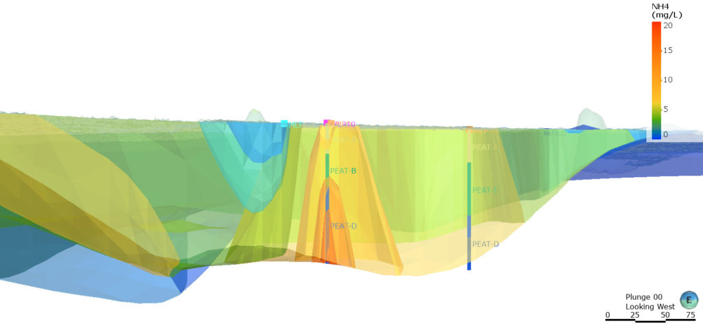
Communicating science in three-dimensional (3D) multimedia is an immersive and interactive way to explore scientific processes (Signals and Communication Technology, 2019). Geovisualization is an emerging 3D multimedia method for visual analysis, synthesis, and presentation of geospatial, geologic, and geophysical data (MacEachren & Kraak, 2001). There is an identified need to develop scientific communication tools to further understand boreal peatland evolution, hydrogeology, ecology, and geochemistry (Bubier et al., 2003) since the International Union of Conservation of Nature asserts that peatlands are among the most valuable ecosystems on Earth, critical for preserving global biodiversity, providing drinking water, minimising flood risk, preventing wildfire, and mitigating climate change (Hama et al., 2000). The intention of this thesis is to communicate a novel approach to geovisualize boreal peatland architecture using Light Detection and Ranging (LiDAR) and Ground Penetrating Radar (GPR). GPR and LiDAR have been used to create 3D subsurface geovisualizations for archaeology (Kenady et al., 2018; Schultz & Martin, 2011) and resource geology (Corradini et al., 2020; Koyan & Tronicke, 2020) although application to peatland hydrogeology is uncommon. Point-source hydrogeological and geochemical data were integrated with 3D geological models to estimate carbon and nitrogen storage in an archetypal boreal peatland near Mariana Lakes, Alberta. Peatland geometry resembled a shallow lake basin with depths greatest in fens (>10 m) and thinnest in bogs (<2 m). Hydraulic conductivity was only a few meters per year and vertical groundwater movement was limited. Sequestered carbon and nutrients increased with depth. The average concentration of dissolved ammonium was 3 grams per cubic metre of peat (g/m3), 5g/m3of Total Kjeldahl Nitrogen, 60g/m3 of dissolved organic carbon and 200g/m3 of dissolved inorganic carbon. Tritium detection from atmospheric atomic weapons radionuclide fallout revealed that in deeper anaerobic peat (catotelm), tritium was absent, signifying groundwater was older than 50 years and not mixed with meteoric waters. Fen catotelm channels are likely acting as gravity-driven hydraulic traps (Tóth, 1999).